Android 9+ · Windows 64-bit · Linux · macOS
XyGrib for Android
Sailors have long used the desktop program
XyGrib (formerly zyGrib)
on Windows, Linux and macOS. It has no mobile version, and people
have been asking for one on sailing forums for years.
MAKGrib is a fork of XyGrib brought to the phone: the same GRIB
engine and the same chart, with a screen rebuilt for a finger and a
moving deck. Desktop builds exist too — it is one program.
What it does
It downloads forecasts straight from the American weather service
NOAA for the patch of sea on your screen, not for half the
world. The file stays on the device and opens again next time you
start: at sea there may be no connection for a week, and that is the
point of the program.
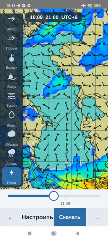
- wind and gusts — barbed arrows over a colour field;
- waves — height, direction and period;
- pressure — isobars over any layer;
- air and sea temperature;
- fog — temperature minus dew point;
- cloud, rain, thunderstorms.
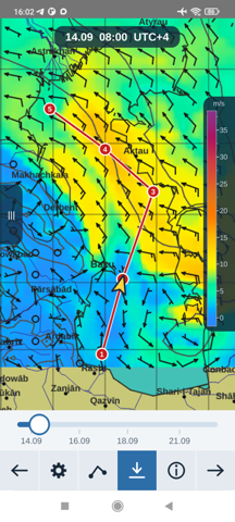
Route and time of arrival
Tap the chart to lay a route, drag the points to adjust. The app
computes the distance along great circles, the passage time at your
speed and the hour of arrival. The vessel moves along the route as
you step through the forecast, so you see which wind it will meet
and where.
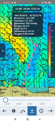
Weather at a point
Hold your finger on the chart and a small window shows the numbers
for that hour: wind and direction, gusts, wave, pressure, air and
sea temperature, cloud and rain.
Where it works
| Sea | Wind, pressure, temperature | Waves |
|---|
| Oceans, Mediterranean, North Sea, Baltic | yes | yes |
| Black, Azov, Caspian | yes | not yet |
NOAA's wave model does not compute enclosed basins. Waves for the
Caspian, Black and Azov seas will come from the German weather
service, whose model does cover them — measured, not assumed.
How it differs from Windy and the rest
Windy is excellent while you have a connection. At sea you do not.
MAKGrib keeps the downloaded forecast on the device and shows it
without a network — that is the difference between checking the
weather and working with a forecast.
No subscription, no account, no advertising, no data collection. The
source is open, so the program cannot be closed down or quietly
turned into a paid service over its users' heads.
Questions
What does it cost?
Nothing. No paid features, no subscription, no ads.
Do I need internet?
Only to download a forecast. After that it lives on the device.
How big is a forecast?
Usually 200 KB to 1 MB, depending on the area, how many days and the
time step.
Can I navigate by it?
No. It is a weather forecast and an aid to planning a passage, not a
navigation instrument and not a substitute for official warnings.
Download
For phones pick arm64-v8a; armeabi-v7a is
for older 32-bit devices.